Below is a review of Perinton from a geological perspective. Please join us in discovering what lies beneath the ground we walk on in Perinton. It is exciting to learn how our town”formed” into the land it is today.
Natural Region
The earth’s surface can be divided into natural regions controlled mostly by the kinds of structures making up the earth’s crust. Construction materials and problems, cultural traits, and industrial or agricultural pursuits are generally more similar within a region than between regions. The United States and Canada are divided into 40 regions called physiographic provinces. Perinton is within the Great Lakes section of the Central Lowlands province.
The Central Lowlands are a vast plain covering 650,000 square miles extending from the Appalachian highlands to the Great Plains (west of the 100th meridian). Outstanding features include: great extent, low altitude and slight local relief, continental climate, great lakes and rivers, a mantle of glacial deposits that largely conceal the underlying rock formations, subsurface structure of thin, broadly warped sedimentary rock formations, and a rich economy well balanced between agriculture, minerals, manufacturing, and transportation.
The Great Lakes section is further distinguished by a plain of glacial till deposited during the most recent ice age. The plain is interrupted by morainal ridges arranged in arcs south of the present Great Lakes. Valleys between the ridges are hummocky with knobs and kettle holes containing ponds or swamps. The Great Lakes themselves are, of course, the most dramatic feature. However, much of the terrain owes its characteristics to even larger lakes which covered the region immediately after the retreat of the last continental glacier.
If you are interested in maps, this link will take you to a web site that has many landform maps of New York.
Color Landform Atlas: New York

Bedrock
The stage was set for the creation of the bedrock beneath our feet when the Iapetu Ocean – a predecessor of today’s Atlantic – began to close about 450 million years ago. The “Atlantic” plate was subducted beneath the North American plate, much as the Pacific plate is being subducted beneath Asia today. And like the Japanese islands today, a series of volcanic barrier islands formed off the cost of North America. Eventually, Africa and Europe collided with the Americas, forming the supercontinent Pangaea.
The force of the collision between Africa and North America folded the earth’s crust, piling up Himalayan- sized mountains (several miles tall!) in what is now western Massachusetts. The Berkshires are the worn remnants of this mighty mountain chain. Slabs of rock broke off these ancestral Berkshires and slid into eastern New York. Alpine geologists call these slabs “klippen”. The Taconic Mountains are a small momento of this event.
Approximately 390 to 450 million years ago Perinton, and this entire region, was covered by a shallow inland sea. Sometimes this tropical ocean was clear and teamed with life. Many of the animals in the sea, such as corals, protected themselves by extracting calcium and dissolved carbon dioxide from the sea and producing hard calcium carbonate shells. When the animals died their shells settled to the sea floor. For longer periods, the sea was murky with the sediment from the eroding ancestral Taconic mountains to the east. These sediments eventually settled to the ocean floor as well.
With the passage of time, the weight of new sediment above and the heat from the earth below compressed and changed these loose aggregations of shells and silt. The shells formed layers of limestone and dolomite while the mud and silt formed shale. As a result the bedrock of western New York resembles a chocolate layer cake: thick shale cake separated by thin limestone frosting. The cake is askew, however, with the layers rising 55 feet for every mile you head north. Where each rock layer intersects the surface it forms an east-west band running across all of western New York.
The creation of the Irondequoit valley has exposed the layers a bit to the south of their average position, and consequently the band of Lockport Dolomite first breaks the surface in northwestern Perinton. Lockport Dolomite is famous as the cap stone of Niagara Falls and the upper falls of the Genesee River in Rochester. A minor outcropping of this rock formation is visible along Irondequoit Creek.
The remainder of Perinton is underlain by shales of the Salina group. The greatest part of the town is underlain by Vernon shale. There is an outcropping of this rock along Thomas Creek and between Waterford Way and the Erie Canal. While the Vernon Shale was being deposited, the first primitive vertebrates, cyathaspid armor-skinned fishes, made their appearance. Finally, in the southeast corner of town, the bedrock isCamillius Shale. This rock is known for its inclusions of salt and gypsum. These deposits formed where arms of the sea were pinched off, and the trapped ocean water evaporated, leaving behind its dissolved minerals.
Between the time these deposits were laid down and approximately 1 million years ago there is almost no geologic record. It is presumed that the entire area was above sea level and erosion smoothed the region. At some point in this period, the Genesee River became established. Rather than flowing along its current course, it most likely flowed east along the current course of Honeoye Creek, and then along the course of Irondequoit creek, turning north near the hamlet of Fishers. During this time, the Genesee cut a gorge through western Perinton, setting the stage for further sculpting by glaciers.
These ancient events had three major impacts on modern Perinton.
- In humid environments such as exist here, alkali elements are leached from the soil by infiltrating rain water. This leads to acid soils. As the dolomite bedrock weathered, calcium carbonate (lime) became incorporated into the soil. This partially compensates for the leaching effect, and produces soils of exceptional fertility.
- Resistant dolomite cap rocks separated by weaker shale leads to the formation of waterfalls. Waterfalls along Irondequoit Creek in Penfield and on the Genesee in Rochester were exploited for water power and greatly stimulated the development of the area.
- An east-west stream flowing on a tilted shale bed erodes south as it erodes down. This process continues until the stream flows with its south bank along a resistant limestone outcropping. This type of erosion results in a series of east-west ridges, with steep northern slopes and gentle southern slopes. These hills are called by their Spanish name, cuestas. The glaciers which covered this region also found the shale outcroppings easy to erode, further deepening the valleys.
- The next resistant formation south of Perinton is formed by the band of Onondaga limestone running between Rush and Avon. The region between Perinton and this escarpment is part of a long lowland containing a series of important wetlands running east-west across the state. The best known of these wetlands are part of the Montezuma Wildlife refuge. The existence of this lowland together with the limestone outcroppings sometimes work together to form unique ecosystems, such as exists in the Bergen Swamp.

Glacial Geology
Virtually all the landforms we observe in Perinton are determined, not by the bedrock or the ancient forces which shaped it, but by events which occurred very recently in geological history.
Approximately 1 million years ago, for reasons which are not yet understood, the climate shifted slightly. More snow fell on to Quebec during the winter than melted in summer. Under the weight of new snow, snow of previous years was compressed to ice. This ice sheet grew year by year until it penetrated deep into what is now the northern United States. At least four separate glacial periods are known to have occurred in the ensuing million years. In this area, each glacier scoured away the evidence of the one previous. The most recent began approximately 125,000 years ago, and at its peak extended south into Pennsylvania. The southern front of the ice sheet was near the current location of the Ohio and Missouri Rivers. It is this glacier which is responsible for all the landforms around us.
During the early stages of its advance, the glacier would take the path of least resistance. Consequently, tongues of ice would extend south through river valleys, such as that of the ancestral Genesee in western Perinton. The ice dramatically deepened and widened the river valleys, and converted them from “V” shaped to “U” shaped. Test borings in the center of Irondequoit Bay, made in preparation for the Bay Bridge, penetrated to below sea level without hitting bedrock. Further to the south, this same scouring action was responsible for the creation of the Finger Lakes.
Eventually the ice sheet attained a thickness of 1000 to 2000 feet, overtopped the highest topography in western New York, and scraping the surface clean of most previous unconsolidated landforms. Most of the current landscape was formed from material deposited from the glacier, called glacial drift. These landforms were created either directly from debris carried by the ice sheet, from sediment carried in meltwater leaving the glacier, or by sediment which filled the lakes that formed in front of the retreating glacier.
Glacial Till
Material deposited directly from the ice sheet is called till. Till is a chaotic mixture of sand, clay, gravel, and stones of all sizes – all the material the glacier scraped up on its travels south. Glacial till is the predominant material in a north-south band through central Perinton as well as in the northeast corner and along the town’s eastern border south of the Erie Canal. This corresponds to the location of the Ontario-Hilton soil association. The southeast and south-central highlands of Perinton are composed of till. Although the exact origin of these highlands is not clear, it is probable that they are either a type of moraine (see description of the formation of the Pinnacle Hills or a series of kames, or a combination of both. Kames are isolated hills formed in areas of dead, wasting ice which is covered with a large quantity of till. They can also form where a stream running along the top of a glacier plummets into a hole in the ice. After the glacier retreats, this leaves behind a conical hill of stream deposited sediment.
The most readily recognizable landform created from till is the drumlin. Drumlins resemble in appearance the bowl of an over-turned spoon. They are oval-shaped with their long axis along the direction of the glacier’s flow. Their north slopes are typically much steeper than their southern slopes. Drumlins are believed to form under the ice while it is flowing south. Under certain conditions of ice thickness and temperature, the ability of the glacier to keep gravel and stones suspended is reduced. The material is “plastered” against the ground and molded into the drumlin’s characteristic streamlined shape by flowing, plastic ice.
Outside the south Perinton highlands, the hills within the area of glacial till are all drumlins. While just east of Perinton is one of the world’s finest examples of a drumlin field, within the Town most drumlins do not have their classic shape. They have been modified by other glacial forces. Perhaps the best example of a drumlin within Perinton is Gerber Hill. Its southern slope cut by Route 31, Gerber Hill is directly north of Pannell Road; the last hill one crosses before entering the town of Macedon.
Glaciofluvial Drift
Material deposited from glacial melt water is called glaciofluvial drift. Since the heaviest material is the first to fall from flowing water, glaciofluvial drift is sorted, producing beds of sand or gravel containing particles of relatively uniform size. Kame deltas and eskers are examples of glaciofluvial drift.
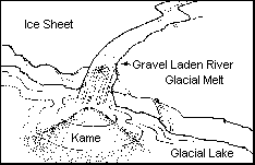
Kames
Kame deltas are formed when glacial streams enter a lake, depositing their load of sediment as a delta. These formations are found along the flanks of the southern highlands. They are coincident with the Palmyra soil association. This association also predominates along the eastern border of Perinton, just north of the canal. Kames are excellent sources of sand and gravel and are often mined. The current location of the Woodcliff Office Park is such a site.
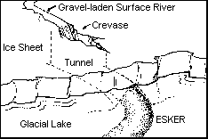
Eskers
Eskers are the gravel beds of streams which flowed under the ice sheet. As fossil stream beds, they form long, sinuous ridges. The best example in Perinton is the ridge cut by Park Road, just west of the fish hatchery in Powder Mill Park. Another esker (perhaps the northern extension of the one just described) can be seen along the south side of Marsh Road between Bushnell’s Basin and Route 31. This esker, known as the Carterville Esker, provided a relatively easy route for the Erie Canal across the Irondequoit Creek valley. A continuation of this esker runs northwest from the corner of Marsh Road and Route 31.
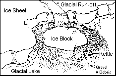
Kettles
Kettles are another glacial land form which has had an impact on the ecological development of Perinton. These are formed when large blocks of ice break from the face of the glacier and are buried in sediment. When these block melt, they leave roughly circular depressions. If these depressions fill with water they are known as kettle lakes. A string of kettles runs down the Irondequoit valley from the Erie Canal to south of Powder Mill Park.
Proglacial Lakes
Approximately 10,000 years ago the last glacier had retreated into Canada. Cubic miles of ice melted. In this part of the country, the drainage is to the north, and so the glacier blocked the escape of its own meltwater. A series of enormous lakes, the greatest series of ice impounded waters known, were formed south of the retreating ice front.
The first lake of consequence to Perinton formed when the ice sheet retreated north of Batavia. Named Lake Warren, it filled the Huron and Erie valleys and extended east to Syracuse. Lake Warren first had its outlet through Michigan and then through Syracuse. The most northerly point above water was Baker Hill, which formed a small island whose shoreline was at an elevation of 900 feet. The plateau southwest of the peak of Baker Hill was smoothed by Lake Warren’s waves.
The glacier paused at the current location of the Pinnacle Hills. Such a pause is caused by new ice flowing in at the same rate ice is melting. All the rubble carried with the new ice was deposited at the meltfront, creating the Pinnacle Hills. This type of geologic formation is known as a recessional moraine. At this point a new pass was exposed near Syracuse, and the lake waters receded to 700 feet to create Lake Dana. The remnants of beaches and deltas formed from the runoff from Turk and Baker Hills can be found at this elevation. Such an area is located just north of Route 96 between Moseley and Turk Hill Roads. Dana also began to drain, but stabilized at an elevation of 640 feet for a time. This would place Briggsborro Drive, McCoords Woods Drive, and the Lodge at Woodcliff near the Lake Dana shore.
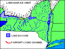
When the ice pulled away from the Pinnacle Hills, yet another, lower channel was exposed and the waters fell below 600 feet. This new lake, called Lake Dawson, had its outflow through what is known as the Fairport-Lyons Channel. This channel began at the present location of theVillage of Fairport and proceeded east through Palmyra, Newark, Lyons, Clyde, finally emptying through the Mohawk Valley. It drained nearly 1000 miles of ice front extending across the Great Lakes basin. The copious waters which rushed through the channel swept away all the glacial drift in its path and carved down into the weak Salina shale. This lowered the Lake Dawson shoreline to 480 feet. The Lake Dawson outflow latter became known as the “Water Level Route”, followed by the Erie Canal and the railroads. Thus, it was the meltwaters in Lake Dawson which provided an economic route for settlers to reach this region and to ship their crops and products east.
Lake Dawson filled the present Irondequoit Valley. Fine sand and silt settled to the lake bottom, virtually filling the valley. These soils comprise the Arkport association and cover most of the area west of Route 96 and south of the Erie Canal. A slightly different environment pertained in the Lake Dawson outflow channel, and the bay which protruded south into the current location of the Whitebrook wetland. Sand and silt settled in these areas as well, but drainage was restricted. Consequently, very poorly drained soils, such as Lamson, formed. The low, flat topography of these glacial lake beds subjects them to frequent flooding by Thomas Creek and Whitebrook, resulting in alluvial soils, such asWayland and Eel. The low areas accumulate organic debris, which is slow to decompose due to the high water table. This results in large areas of muck. The muck is sometimes underlain by marl; this is described in more detail in the discussion of bog vegetation.
The last of these glacial lakes was Lake Iroquois. The Lake’s most prominent feature is its shoreline which nearly encircles the Ontario Basin. Unrivalled in its clarity, the shoreline is characterized by a heavy, wave-built gravel ridge. The location of today’s Ridge Road, this ancient beach has been used as an east-west transportation route for as long as humans have occupied the region. Wave action also produced an abundance of small, smooth cobblestones. Between 1825 and 1860, these were used to build cobblestone houses in a variety of patterns and with an unusually high level of craftsmanship.
The glacial carving of the Irondequoit Valley allowed Lake Iroquois to inundate the valley as far south as the Erie Canal. As with Lake Dawson before it, sand and silt settled out of the Iroquois waters, forming a sand plain in western Perinton, north of the Erie Canal. These sands form the Colonie-Elnora soil association. The topography in this region is caused by subsequent erosion cutting down into the flat lake bed.
The depth to bedrock within the Irondequoit valley in Perinton is not known exactly, but it is at least 150 feet. This geological formation, a deep chasm cut in bedrock first by the Genesee, then by the glacier, and now filled with highly permeable soils, forms the Irondo-Genesee Buried Valley Aquifer. It is one of 18 “primary water supply aquifers” in upstate New York. East Rochester pulls over 8 million gallons of water per day from this aquifer. Recharge of the aquifer is primarily from rainfall on the western slopes of Turk Hill. Recharge rate is controlled by rainfall and evapotranspiration. Consequently, most recharge occurs during the non-growing season (November – April).
The forces of the ice age dominate the development of Perinton even today. Perinton’s soils, aquifers and topography were created during the ice age.
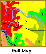
- Soils:
- The lake lain soils of the Colonie-Elnora (1) and Arkport (2) associations have high permeability. The disposal of septic effluent in these soils may create a pollution hazard. These soils are easily eroded, by both water and wind. Colonie soil is acid and droughty which makes vegetation growth difficult.
- The glacial outwash soils of the Palmyra (3) association are less easily eroded, except where steep. They have high bearing capacity and adequate strength for foundations and other structures. They are rapidly permeable and may present a pollution hazard. They are excellent sources of sand and gravel and are well suited for agriculture. Where drainage is poor (4), Perinton’s largest aggregation of wetlands exist. While generally unsuited for development or agriculture, these areas are crucial for water purification, flood protection, and wildlife habitat. South of the Whitebrook wetlands, where the drainage is better, the soils are excellent for growing vegetables.
- The glacial till of the Ontario-Hilton (5) association have adequate strength and high bearing capacity. Erosion is a problem when slopes are steep. They often have low permeability, and therefore present restrictions for locating septic systems. They are well suited for agriculture, but have a high seasonal water table in places.
- Water supply:
- The buried valley of the pre-glacial Genesee River is a major aquifer in the region. While not used extensively within Perinton, it is critical to our neighbors in East Rochester and Webster.
- Topography:
- One of the striking features of Perinton is the variety of its terrain. Steep hills, rolling farmland, and wetlands are all a glacial legacy. This scenic character attracts people to the Town and improves the quality of life.
- The hills and valleys sculpted by glacial processes direct our road systems and limit the areas which can be economically served by sewers. They also naturally cluster development, creating neighborhoods and limiting suburban sprawl. The steep slopes are generally difficult to develop without causing erosion problems.
With the application of sufficient resources, we can overcome the limitations and benefits of our glacial heritage. Or we can use them to our advantage.

Flora
Since vegetation reflects the environment, the world can be divided into regions based on characteristic vegetation. Forest type, where forests exist, is ideal for this purpose. However, authorities disagree on the proper classification of our region. Partially this results from arbitrary choices of how to group species, but more generally it can be said to be due to the large variety of species present in our forests. It can be argued that this area is an ecotone; a region of transition between the boreal forests of the north and the drier, warmer forests of the south and west. In addition, the relatively short time which has elapsed since the retreat of the last ice sheet admits a multitude of microclimates which locally favor certain species over others.
Arguably, the best classification of the forests of this region is mixed deciduous forest. This name reflects the variety and variability of the species present. This forest extends southwestward across much of Ohio and Indiana, and into Illinois. It corresponds to the Central Lowlands physiographic province of the United States, which is predominately in the Midwest, but encompasses western New York as a north-easterly peninsula.
The mixed deciduous forest is very productive. Organisms exploit the vertical dimension: biological activity flourishes in the canopy, the understory, the shrub layer, the herb/fern layer, and in the topsoil. They also exploit the temporal dimension, for example spring wildflowers take advantage of the sunlight available before the canopy is in full leaf. Some plants, such as the wild grape and Virginia creeper, use the trees to advantage and climb their way to sunlight. All this activity requires energy. It has been estimated that the total energy used by plants and animals in one acre of beech-maple forest (a subset of the mixed deciduous forest) each year is equal to that needed to supply an average home with electricity for nearly half a century.
Local conditions cause some species of the mixed deciduous forest to be favored over others. Because of this, two forest types, beech-maple and upland oak/oak-hickory, can be recognized within the Town of Perinton. Because of extensive clearing for agriculture, and more recently for suburban development, we must rely on the records of the first surveyors to determine the natural range of these forests. Fortunately, these records are quite complete and detailed. In the following paragraphs, we refer to the natural, pre-settlement, extent of these forests.
Beech Maple Forest
The largest area (47%) of Perinton was covered by beech-sugar maple forest. If an imaginary line is drawn from East Rochester to the southeast corner of the Town, the beech-maple forest dominates the area north of that line. This forest thrives where the soil is dominantly glacial till. Beech and sugar maple each individually comprise over 25% of the trees in the forest, basswood runs a distant third, with ironwood, white ash, and red maple also in evidence. Hart’s Woods is an excellent example of a beech-maple forest.
The beech-maple forest is a clear climax community. Both species are shade tolerant, thereby preventing the invasion of less shade tolerant species. Typical understory trees are absent, their place taken by immature beech and maple. They will live, growing quite slowly, in the shade of their elders for many years. A chance windfall or death of a larger tree will stimulate rapid growth, and a young tree will take its place in the canopy. Beech, which can reproduce from root sprouts, is particularly suited to this shady environment. One peculiarity: beech reproduce best in the shade of a maple, and maple best in the shade of a beech. As a result, which of the two is dominant in a given forest oscillates from generation to generation.
Oak Hickory Forest
Following in close second is the upland oak/oak-hickory forest, which once covered 43% of Perinton. It is located predominantly south of the imaginary diagonal line described above. These forests are characterized by a diversity of species, including (in order of prevalence) red oak, white oak, black oak, and shagbark hickory, none of which comprise even 25% of the total. This forest dominates where the soil is deficient in moisture. Such a condition exists in the higher sand plains of the Irondequoit valley, where it is due to highly permeable soils, and in the highlands of southern Perinton, where surface drainage is very efficient. Hickory is locally dominant over the oaks in southern Perinton.
The drier, morainal regions of southeastern Perinton would have been classified as oak-chestnut forest before the introduction of the chestnut blight in 1906. Chestnut roots are resistant to the blight fungus and continue to sprout. As a result what was once a dominant and dramatic tree of the canopy is now an understory species.
The dominant trees of the oak-hickory forest are nut producers. Consequently, this is excellent wildlife habitat, with species like the wild turkey making a comeback.
Some invasion of the oak-hickory forest by the beech-maple forest has been observed. This could be because the oak-hickory forest is not the climax type for this region, but a remnant from a previous, drier time. Evidence that this region was once drier is discussed below. Another explanation is that the oaks, not being shade tolerant, require an occasional thinning by fire to remain dominant.
Minor Vegetative Communities
The remaining vegetative communities, while covering only 10% of the town, are interesting and important as indicators of environmentally sensitive or difficult to develop areas. They also provide clues to the environmental history of the region.
Bog Forests
Bog forests cover about 4% of Perinton. Bogs form in kettles or depressions between drumlins where there is very poor or no surface drainage. They are small in area. Saturated soils lack oxygen; this slows the decomposition of organic matter leading to the formation of muck and peat. The dominant species are those generally associated with the boreal forest: bogs are relics from early post-glacial times. Bogs are characterized by a sphagnum mat in which cranberry and several other characteristic species grow. The bogs are eventually invaded by bog heaths, such as leatherleaf, and then by shrubs such as high bush blueberry. The first trees to move in are tamarack. In the kettles of Powder Mill Park, where there is no surface drainage, succession has stopped at this point.
In addition to the kettle complex near Powder Mill Park, bog vegetation can be found within the Thomas Creek, Whitebrook and nearby wetlands. Here it is located in abandoned stream channels, where surface drainage, while very poor, none the less exists. Under these conditions arbor vitae replaced tamarack as the dominant tree species and most of the species of the bog meadow and bog shrubs disappeared. The best example of an arbor vitae swamp is just west of the High Acres landfill on the south side of Perinton Parkway.
Muck and peat are sometimes found over a bed of marl. Marl is a white, clay-like material composed almost entirely of calcium carbonate. Small fragments of organic matter and whole mollusk shells are thoroughly intermixed.
Marl probably represents an early stage in bog development, where the water was deep enough to discourage the growth of large plants. The dominant plant life was algae, and of these the stoneworts are particularly associated with marl formation. Due to the underlying bedrock, the waters of this region are rich in calcium bicarbonate. As a result of photosynthesis, the stoneworts would remove carbon dioxide from the water (lowering the solubility of calcium carbonate) and release oxygen. The oxygen reacts with the calcium bicarbonate creating calcium carbonate, which soon forms a thick coating on the plant. This process can be seen today where streams have been dammed in the southwestern part of the county. When the plants died, the organic mater quickly decomposed, leaving the marl beds.
Marl has been mined as a source of lime for agricultural use and as a component of Portland Cement. Marl can be observed in the stream banks just south of the Erie Canal on the Macedon side of the Perinton-Macedon border.
Northern Hardwood Forest
Another relic from an older, cooler time, although considerably more wide spread in Monroe County than bogs, is the hemlock-northern hardwood forest. Most prevalent north of the Lake Iroquois shoreline in the northeast and northwest corners of the county, the hemlock-northern hardwood forest persists in the shaded ravines along Irondequoit creek. In this restricted location, it covers roughly 4% of Perinton. It is the final stage of succession as a bog fills, giving way to the beech-maple forest only as the climate warms.
The great overlap in species present in the hemlock-northern hardwood forest and the beech-maple forest leads some authorities to classify this region as part of the northern hardwoods forest, rather than the mixed deciduous forest.
Swamp Forest
Approximately 3% of Perinton is subjected to flooding with sufficient frequency to develop a swamp forest. The dominant tree species is red maple, with silver maple, basswood, and ash also prevalent. Cottonwood, silver maple, black willow, and sycamore follow the stream banks and are prevalent in the wetter areas. Swamp forests are associated with the Whitebrook and Thomas Creek wetlands. In some cases swamp forest replaced bog vegetation when wet conditions returned after a dry interlude.
The uplands of this area were most suitable for agriculture and were cleared first, so the swamp forest is well represented in the woodlots of Monroe County.
Marsh
Marshes exist in areas too wet for the swamp forest. Progressing from open water to the swamp forest, one first encounters floating vegetation such as duckweed, followed by submerged plants such as the stoneworts and pondweeds. In shallow waters emergent vegetation such as pond lilies, water lilies and cattails predominate. Cattails join with bulrushes, rushes, and sedges to form the true marsh, which, while it has continuously wet soil, does not have standing water year round. Under drier conditions the marsh gives way to the marsh meadow, which is composed almost entirely of grasses and sedges. In wetter areas the sedges form tussocks which provide a place for less water tolerant species to root.
Oak Openings
By far the rarest and most unusual plant community in Perinton is the oak opening. These are small areas, generally within an oak forest, which remain devoid of trees. They are too dry, and sometimes too alkaline, for even the most drought tolerant oaks to survive. The characteristic plants include Indian grass, tall bluestem and little bluestem. These are all grasses characteristic of the dry prairies of the great plains – they are far from their natural home! The accepted explanation is that between the end of the last ice age and current time there was a brief dry (and perhaps warm) spell known as a xeric period. During this period the western prairies spread east in a “prairie peninsula” which covered most of this region. Pollen taken from core samples drilled into bogs provide additional support for this theory. When the climate became more humid, relics of this previous era persisted where local conditions prevented the intrusion of the forest. Oak openings are small, isolated patches. They exist (or existed) on the dry sands along Irondequoit creek, where the creek bends into Pittsford, and in southeast Perinton.
References
- Broughton, J.G. et. al., Geology of New York, A Short Account, New York State Museum and Science Service, Albany 1966.
- Davis, C.A., A Contribution to the Natural History of Marl, Journal of Geology, 8, 485-497, 1900.
- Fairchild, H.L., Geologic Story of the Genesee Valley and Western New York, published by the author, 1928.
- Heffner, R.L. and Goodman, S.D., Soil Survey of Monroe County, New York, U.S. Department of Agriculture, Soil Conservation Service, 1973.
- Hunt, C.B., Natural Regions of the United States and Canada, W.H. Freeman & Co., New York 1974.
- Kappel W.M. and Young, R.A., Glacial History and Geohydrology of the Irondequoit Creek Valley, Monroe County, New York, U.S. Geological Survey Water-Resources Investigations Report 88-4145, 1989.
- Kricher, J.C. and Morrison, G., Eastern Forests, Houghton Mifflin Co., Boston 1988.
- Martin, D.B., et. al., Planning Inventory, Town of Perinton, Monroe County Planning Council, 1967.
- Selby, M.J., Earth’s Changing Surface, Clarendon Press, Oxford 1985.
- Shanks, R.E., An Ecological Survey of the Vegetation of Monroe County, Proc. Rochester Academy of Science, 11(3), 1966.
- Sutton, A. and Sutton, M., Eastern Forests, Alfred Knopf, New York 1985.
- Van Diver, B.B., Roadside Geology of New York, Mountain Press, Missoula, 1985.
- von Engeln, O.D., The Finger Lakes Region, Its Origin and Nature, Cornell University Press, Ithaca, NY 1961.